Manaslu (8,163 m) — the world's 8th highest mountain and Nepal's most majestic peak mass — up close from its base camp at 4,480 m by private helicopter from Kathmandu. The mountain that Japanese climbers first summited in 1956, after four failed expeditions, looms above the Buri Gandaki valley in one of Nepal's least-visited yet most spectacular mountain landscapes. Manaslu's north and south faces from the air, the Manaslu Glacier terminus, and the panoramic Gorkha Himalaya from 4,480 m.
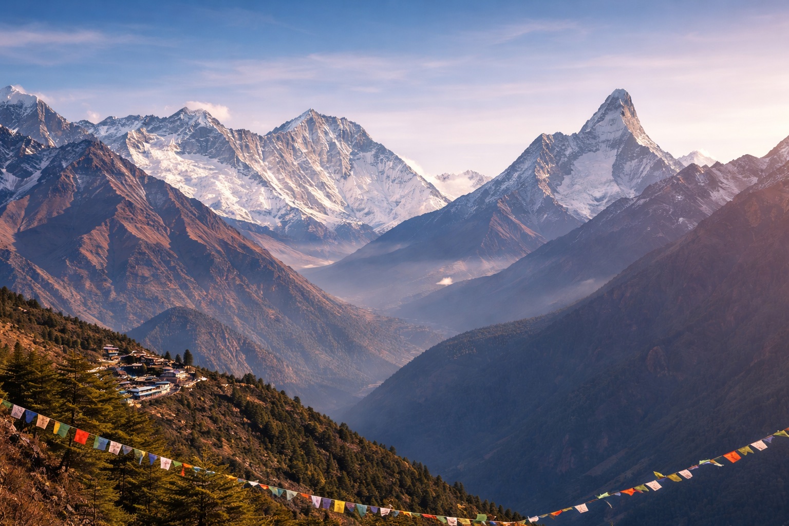
Manaslu (8,163 m) is the world's eighth highest mountain — a massive, multi-summit peak mass that dominates the skyline of Gorkha District in west-central Nepal, yet receives only a fraction of the visitor attention directed at Everest or Annapurna despite being, by any objective measure, one of the most spectacular mountains on Earth. The Manaslu Base Camp Helicopter Tour delivers you from Kathmandu to the mountain's base camp at 4,480 m in a single morning — the flight northeast from Kathmandu across the Prithvi Highway corridor and into the Buri Gandaki valley providing one of the most dramatic approaches to an 8,000-metre peak available by air in Nepal.
The name Manaslu derives from the Sanskrit Manasa — "mountain of the spirit" or "intellect" — and the name, despite its ancient origins, is apt. From all approach angles, Manaslu presents a quality of architectural coherence unusual for 8,000-metre peaks: the mountain rises from a relatively flat high-altitude plateau to a sharp summit pyramid through a series of technically demanding ridges and faces that create, from the base camp viewpoint, a visual geometry more reminiscent of a Gothic cathedral than the sprawling massifs of Dhaulagiri or Kangchenjunga. The Manaslu Glacier — the main approach route for all climbing expeditions — flows directly south from the summit to the base camp area, its surface a highway of seracs, crevasses, and ice towers that reflect the afternoon sun in shifting patterns of blue, white, and grey.
Manaslu has a particular significance in Himalayan climbing history as Japan's "own" 8,000-metre mountain. The first successful ascent — on 9 May 1956, by Toshio Imanishi and Gyalzen Norbu Sherpa during the third Japanese expedition — came after four years of failed attempts by Japanese mountaineers who had requested exclusive access from the Nepali government and committed to returning each year until the summit was reached. The story of the Japanese Manaslu campaigns (1952–1956) is one of the most compelling narratives in Himalayan mountaineering history — one marred by the 1972 disaster in which eleven climbers and Sherpa were killed in an avalanche — and the mountain remains associated with Japan in the Himalayan climbing world. The base camp area has the characteristic atmosphere of all high-altitude expedition camps: the old fixed rope sections, the cairns, and the prayer flags of successive expeditions create a landscape that reads as human struggle against extraordinary natural scale.
The helicopter flight from Kathmandu to Manaslu Base Camp follows the Buri Gandaki valley — the river system that drains the entire Manaslu Conservation Area from the Tibetan plateau south to the Marsyangdi confluence. The Buri Gandaki is one of Nepal's most spectacular yet least-visited river valleys: a deep gorge through the middle Himalayan ranges that transitions from subtropical terraced farmland in the lower sections to the dry, high-altitude terrain of the Manaslu Conservation Area in the upper reaches. The helicopter approach up the valley reveals the gorge's structure — the vertical walls narrowing and rising as the aircraft moves north — before the valley opens into the high cirque of the Manaslu Conservation Area and the mountain itself appears above, filling the northern horizon with 4,000 metres of rock and ice.
The helicopter flight to Manaslu Base Camp passes over the entrance to the Tsum Valley — a restricted, hidden valley on the Manaslu circuit's northern extension that was opened to trekkers only in 2008. The Tsum Valley is inhabited by the Tsumba people, a Tibetan Buddhist community who have maintained a culture of near-complete isolation for centuries, practising a form of Tibetan Buddhism that preserves traditions lost or modified elsewhere in the Himalayan world. From the helicopter, the valley's entrance — a narrow gorge opening in the Buri Gandaki's northern wall — is visible before the main Manaslu cirque opens ahead. The Tsum Valley communities of Chhokangparo and Nile are visible from the air on the upper valley terraces.
The helicopter approach to the base camp passes the village of Lho (3,180 m) — the principal village of the Manaslu Circuit's upper section and the community with the finest direct view of Manaslu's south face from the ground. The Ribung Gompa at Lho — a 17th-century Buddhist monastery perched on a moraine above the village — is visible from the helicopter as a white-walled structure against the grey mountain backdrop. The Manaslu Circuit itself (16–20 days, requiring permits) is visible in its entirety from the helicopter: the valley system, the Larke Pass (5,106 m), and the relationship of the circuit trail to the mountain above provide a geographical perspective that no ground position can match.
The name Manaslu derives from the Sanskrit word Manasa, meaning "intellect" or "spirit." The mountain was given this name by the local communities of the Buri Gandaki valley — the Gurung and Tibetan Buddhist peoples who have lived in its shadow for centuries — who observed the mountain's tendency to generate weather: clouds forming around the summit, storms building on the face, and the specific quality of light and atmosphere that the mountain creates in the valley below. The name was adopted into the Western mountaineering record when the first Western surveys of the area were conducted in the 1940s–50s. The spiritual dimension of the name resonates with the mountain's Buddhist context — the Manaslu Conservation Area is home to dozens of ancient Buddhist gompas and is deeply embedded in the Tibetan Buddhist sacred geography of the region.
The Manaslu Conservation Area (MCAP) entry permit is required for all visitors to the area, including those arriving by helicopter. The MCAP permit costs USD 30 per person per week and is included in our helicopter tour price. The restricted area of Upper Manaslu (above Samagaon, including the Tsum Valley and the northern approach to the mountain) requires an additional restricted area permit, but the standard helicopter tour destination (Manaslu Base Camp at 4,480 m, approached via the main southern valley) does not require the restricted permit. Our team handles all permit arrangements before departure.
The Manaslu tour offers a genuinely different experience from the EBC and ABC tours: a less-crowded mountain setting (Manaslu receives only a fraction of the visitors of Everest or Annapurna), a more dramatic approach valley (the Buri Gandaki gorge), and a mountain that most international visitors to Nepal have never seen up close despite it being the world's 8th highest peak. The EBC tour (5,364–5,500 m landing) is the highest-altitude helicopter experience in Nepal and has the fame of the world's highest mountain. The ABC tour (4,130 m) delivers the famous 360-degree Annapurna Sanctuary. The Manaslu tour (4,480 m) is the right choice for travellers who want an 8,000-metre peak experience with fewer crowds, a more adventurous approach, and a setting that genuinely feels undiscovered.
Yes — the "fly in, trek out" or "fly in, acclimatise, trek section" combinations are very popular for the Manaslu area. The most requested combination is: helicopter to Manaslu Base Camp (Day 1), then trek the southern section of the Manaslu Circuit back to Arughat or Soti Khola over 5–7 days. Alternatively, fly in to Samagaon (the main village below the base camp, accessible by helicopter) and spend 4–5 days exploring the Manaslu area on foot before returning by helicopter. We arrange all combinations — enquire for pricing and itinerary specifics.
October and November (post-monsoon) provide the clearest views of Manaslu — the mountain's south face is typically free of cloud in the morning, the air has exceptional clarity after the monsoon rains have washed the atmosphere, and the autumn light on the rock and ice is photographically outstanding. March–May (spring) is the second-best window: the Buri Gandaki valley forests are in bloom, the base camp area is warmer than in October, and the spring expeditions are often in residence (providing additional atmosphere). The monsoon (June–September) makes the Buri Gandaki valley heavily clouded and the helicopter tour unreliable.