Dhaulagiri (8,167 m) — the world's 7th highest mountain and one of the most technically demanding 8,000-metre peaks — from its high-altitude base camp at 4,750 m by private helicopter from Pokhara. The "White Mountain" that Himalayan explorer Arnold Heim called the most beautiful in the world rises above the Myagdi valley in a colossal north face of rock and ice. The Dhaulagiri Icefall, the French Col, and the panoramic Dhaulagiri massif from Pokhara in under 90 minutes round trip.
Dhaulagiri (8,167 m) — the name means "White Mountain" in Sanskrit, and the description is accurate: the mountain presents, from all approach angles, an overwhelming mass of snow and ice that seems to belong to a different scale from the surrounding landscape. The world's seventh highest peak rises almost directly above the Kali Gandaki gorge between the Annapurna range to the east and the Dhaulagiri range proper to the west — a geographical position that makes it visible from an extraordinary range of viewpoints across Pokhara, the Annapurna Circuit, and the Mustang valley, yet approached by ground only via demanding technical terrain that restricts the base camp to experienced trekkers and climbers. The Dhaulagiri Base Camp Helicopter Tour from Pokhara delivers you to the mountain's base camp (4,750 m) — the highest landing point of any Nepal helicopter day-tour outside the Khumbu — in a single morning.
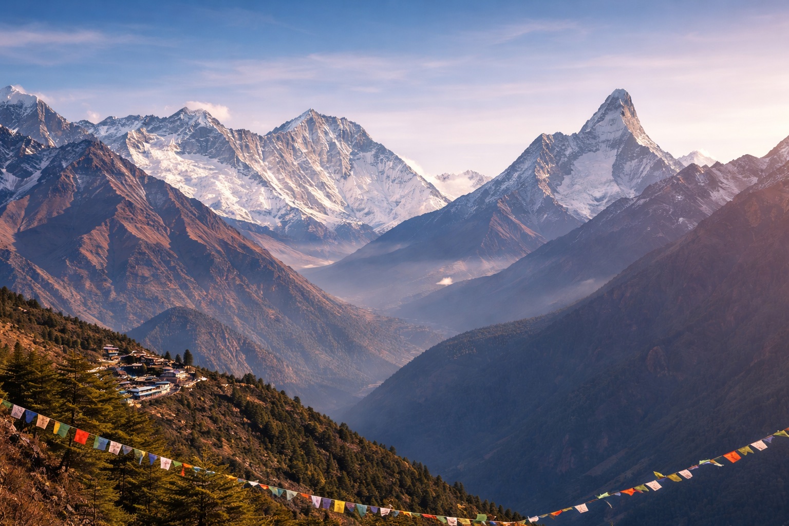
The Dhaulagiri northeast face, which the base camp faces directly, is one of the most technically formidable walls in the Himalaya: 4,000 metres of vertical rock and ice from the Kali Gandaki floor to the summit, with the Dhaulagiri Icefall — the chaotic cascade of seracs and crevasses that guards all approaches to the upper mountain — clearly visible from the base camp area. The icefall's visual scale, experienced from the 4,750 m base camp with the summit pyramid still 3,400 metres above you, creates one of the most visceral encounters with Himalayan scale available in Nepal — the mountain does not look distant or photogenic from this position; it looks immediate, massive, and physically overwhelming in a way that fundamentally changes your understanding of what 8,000 metres means.
Dhaulagiri was first climbed on 13 May 1960 by a Swiss-Austrian expedition led by Max Eiselin, via the northeast ridge — ending a decade of failed attempts by multiple nations that had established the mountain's reputation as one of the most serious technical objectives in the Himalaya. The 1960 ascent used, for the first time in 8,000-metre mountaineering, an aircraft (a Pilatus Porter) for logistics support — landing supplies directly at the base camp, a precedent for the helicopter operations that now service the mountain. The mountain's south face — a 4,200-metre continuous ice wall — remains one of the most formidable unclimbed challenges in Himalayan mountaineering. French climbers have a particular historical connection to Dhaulagiri, having made the first reconnaissance (1950, Maurice Herzog's Annapurna expedition surveyed Dhaulagiri before deciding on Annapurna) and multiple subsequent ascent attempts that shaped the understanding of the mountain's structure.
The French Col (5,360 m) — the high pass at the head of the Chhonbardan Glacier that provides access to the upper Dhaulagiri northeast ridge — is visible from the helicopter during the approach to the base camp. The col was named by the 1954 French expedition that used it as a key logistical route and was the site of one of the worst disasters in early Himalayan climbing history: the 1969 American Dhaulagiri expedition, in which seven climbers and two Sherpa were killed in an avalanche that swept the col. The Chhonbardan Glacier — the principal glacier in the Dhaulagiri base camp area — is visible in its full extent from the helicopter approach, the moraine-covered lower section giving way to the clean ice of the upper glacier in a gradient of grey, white, and blue that changes character through the day as the light angle shifts.
Northeast of the base camp, between Dhaulagiri and the Tukuche Peak (6,920 m), lies the Hidden Valley (4,850 m) — a remote glacial plateau accessible only via the French Col and used by trekkers on the challenging Dhaulagiri Circuit as a high camp between the eastern and western approaches. From the helicopter, the Hidden Valley's plateau is visible in clear conditions as a flat snow field hanging between the ridges — one of the few genuinely flat surfaces above 4,000 m in the Nepalese Himalaya and a feature that gives the Dhaulagiri base camp area a spatial complexity unusual among Nepal's great mountain settings.
The Dhaulagiri Base Camp landing at 4,750 m is the highest helicopter landing point in Nepal outside the Khumbu (where Kala Patthar at 5,500 m and Everest Base Camp at 5,364 m are higher). It is higher than the Annapurna Base Camp landing (4,130 m), the Upper Mustang landing (3,840 m), the Gosaikunda landing (4,380 m), and the Manaslu Base Camp landing (4,480 m). At 4,750 m, the altitude is immediately and physically apparent — breathing is effortful, the sky is distinctly darker blue than at lower elevations, and the cold is more intense than any other Nepal helicopter day-tour. The ground stop of 45–60 minutes is designed to be sufficient for the experience without exposing passengers to undue altitude risk. Most healthy adults tolerate 4,750 m well for under an hour.
No — the helicopter tour requires no mountaineering experience or technical skill. You fly to the base camp, walk on level to gently sloping terrain in the immediate base camp area, and return by helicopter. The only physical requirements are the ability to walk slowly on rocky terrain for 30–45 minutes and a tolerance for high altitude (4,750 m). The experience is appropriate for any physically healthy adult. The mountain itself, visible directly overhead, is the technical challenge — not the tour. Many Dhaulagiri helicopter tour clients have no mountaineering background at all and choose the tour specifically to see the mountain that many experienced climbers describe as the most imposing face in the Himalaya.
Yes — in clear conditions, the Annapurna massif is visible from the Dhaulagiri base camp area to the east. Annapurna I (8,091 m) and Annapurna South (7,219 m) are visible across the Kali Gandaki gorge, which divides the Dhaulagiri range from the Annapurna range. The visual comparison of the two 8,000-metre peaks from this angle — Dhaulagiri directly overhead to the north and Annapurna across the gorge to the east — is one of the most dramatic mountain panoramas available in Nepal and a direct confirmation of the Kali Gandaki's status as the world's deepest valley (flanked by these two summits).
Yes — a combined Pokhara–Dhaulagiri BC–Annapurna BC–Pokhara itinerary is possible as a single-day tour with two mountain landing stops, subject to pilot schedule and weather. The combined tour adds approximately 90 minutes of flying time and an additional ground stop at ABC (4,130 m). This combination provides the extraordinary experience of seeing both flanks of the Kali Gandaki — the world's deepest valley — from above 4,000 m on the same morning, comparing the two 8,000-metre peaks that form the valley walls. Enquire for the combined pricing.