Baruntse (7,129 m) is Nepal's highest trekking peak and the finest 7,000-metre objective for alpinists stepping beyond the standard trekking peaks. Set in the remote Makalu-Barun National Park between the Everest and Makalu massifs, the peak offers a technically engaging West Col approach with panoramic views of four 8,000-metre giants — Everest, Lhotse, Makalu, and Cho Oyu — from the summit ridge.
Baruntse (7,129 m) is the highest of Nepal's officially designated trekking peaks and one of the finest mountaineering objectives in the Himalaya for climbers who have outgrown the standard 6,000-metre peaks (Island Peak, Mera Peak, Lobuche) but are not yet committed to the full logistical and financial weight of an 8,000-metre expedition. At 7,129 m, Baruntse sits at an elevation where genuine altitude physiology becomes decisive — it cannot be climbed without proper acclimatisation, cannot be treated as a walk-up, and requires the full range of technical alpine skills. Yet it is accessible with the right preparation and delivers a summit experience — surrounded by four of the world's fourteen 8,000-metre peaks — that rivals the view from any mountain on Earth.
The mountain lies in the heart of the Makalu-Barun National Park — one of Nepal's most remote and ecologically significant protected areas, forming a continuous wilderness corridor with Tibet's Qomolangma National Nature Reserve to the north. The Barun valley approach is genuinely wild: pristine forest, glacial rivers, and a near-complete absence of the tea house tourism infrastructure that characterises the Everest and Annapurna corridors. Baruntse is for climbers who want both the altitude and the remoteness.
The standard route approaches via the West Col (6,143 m) — a high pass between Baruntse and the Amphu Labtsa — and ascends the broad northwest face and summit ridge to the top. From Base Camp at approximately 5,400 m on the Baruntse glacier, the route involves:
Approach to West Col (6,143 m): a sustained glacier ascent requiring crampons, ice axe, and fixed-rope competence. The West Col itself is a narrow snow saddle with drop-offs on both sides — the most exposed section of the lower route.
Northwest Ridge (6,143–7,000 m): above the West Col, the route follows the broad snow and mixed-ice northwest ridge to the summit. The ridge is sustained at 40–50 degrees with sections of steeper ice requiring front-pointing. Crevasse hazard is present on the upper glacier approaches to the ridge.
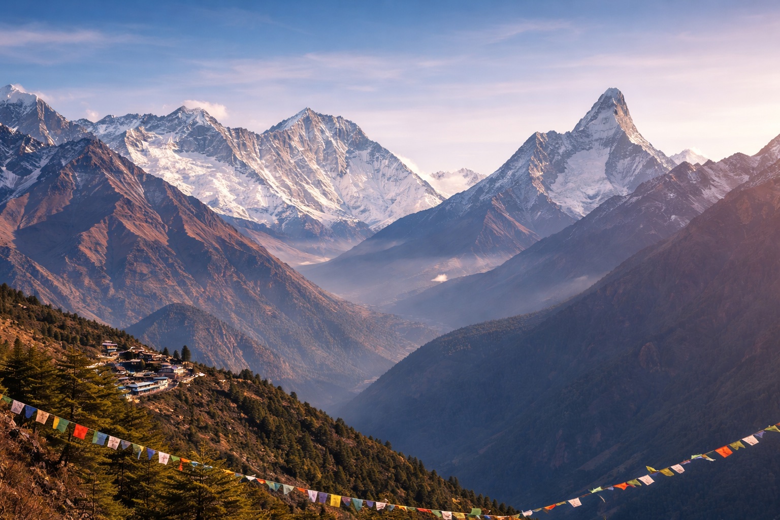
Summit (7,129 m): the summit ridge is a narrow snow arête with dramatic drops on both sides. The 360-degree view encompasses Everest (8,849 m), Lhotse (8,516 m), Makalu (8,463 m) to the north and northwest, Cho Oyu (8,188 m) to the west, Ama Dablam to the northwest, and the entire Barun glacier valley system below — one of the most complete 8,000-metre panoramas available from any summit of this elevation.
The approach to Baruntse Base Camp follows the Arun and Barun river valleys from Tumlingtar (the nearest airport, serviced by daily flights from Kathmandu) through increasingly remote and spectacular terrain. The lower Arun valley is subtropical — banana groves, rice terraces, and Rai ethnic villages — while the middle Barun is temperate forest of oak, maple, and rhododendron. Above the Barun valley head, the terrain transitions to high alpine: yak pastures, glacial moraines, and the wild upper Barun valley where the approach to Base Camp winds through the most pristine high-altitude wilderness in eastern Nepal.
This approach is, by every account, one of the most beautiful in Nepal. The Makalu-Barun National Park sees a fraction of the visitor numbers of the Everest and Annapurna regions — perhaps 2,000–3,000 trekkers and climbers annually — which means the villages along the approach have not been commercially developed and the wilderness zones are genuinely undisturbed.
Many serious Himalayan mountaineers use Baruntse as the final preparatory step before their first 8,000-metre expedition. The mountain delivers everything that the standard trekking peaks do not: genuine altitude above 7,000 m where acclimatisation must be thorough and cannot be compressed, sustained technical terrain on the upper ridge where errors are consequential, and a summit that cannot be reached by sheer determination without the physiological adaptation that only comes from correctly paced high-altitude experience. Climbers who have summited Baruntse are genuinely prepared for Manaslu or Cho Oyu in a way that Island Peak summiteers are not.
Island Peak (6,189 m) and Mera Peak (6,476 m) are the entry-level Himalayan trekking peaks — technically straightforward once you're acclimatised, with manageable objective hazards and well-established tea house infrastructure on approach. Baruntse is in a genuinely different category: at 7,129 m, it requires 2–3 more acclimatisation days above Island Peak's maximum elevation, the West Col section involves sustained 50-degree ice climbing that Island Peak does not, and the commitment of the remote Barun valley approach with camping above Base Camp adds a wilderness dimension that the Khumbu trekking peaks lack. Climbers who found Island Peak or Mera Peak straightforward and are looking for a serious next step should consider Baruntse their natural objective before attempting an 8,000-metre peak.
The Makalu-Barun National Park is one of Nepal's most remote protected areas — accessible only via Tumlingtar Airport (daily flights from Kathmandu) and a 7–8 day approach through valleys that see perhaps 2,000–3,000 visitors annually. There are basic tea houses in the lower valley villages (Seduwa, Tashigaon) but the upper Barun above the tree line is camping-only terrain. Mobile phone signal disappears above Tashigaon. Weather delays at Tumlingtar Airport (common in winter and monsoon) can affect the schedule — we build 2 contingency days into the itinerary.
Supplemental oxygen is not standard practice for Baruntse (7,129 m) — the summit elevation is below the threshold where oxygen becomes physiologically essential for well-acclimatised climbers. We carry emergency oxygen at Base Camp. Individual climbers with prior altitude illness episodes or specific medical indications may wish to carry a personal oxygen bottle for the summit day — discuss this during the booking process. Thorough acclimatisation (the 3-day Base Camp rest plus the West Col rotation) is the primary tool for managing altitude risk on Baruntse.
Yes — and this is one of Nepal's finest expedition combinations. The Amphu Labtsa Pass (5,780 m) connects the Barun valley (Baruntse approach) with the Chhukung valley in the Khumbu — crossing from the Baruntse side to the Island Peak/EBC side via a challenging high pass. Climbers who summit Baruntse and then cross the Amphu Labtsa to the Khumbu complete one of the most demanding and spectacular multi-peak traverses in Nepal. This combination requires excellent technical skills, experienced guides, and additional days — it is an advanced option we can arrange for qualified parties.
The Nepal Mountaineering Association permit for Baruntse costs USD 1,500 per person (autumn season) and USD 1,500 (spring season). This is included in our package price. Additional fees include Makalu-Barun National Park entry (NPR 3,000), TIMS card, and liaison officer costs. Baruntse is classified as a trekking peak despite its 7,129 m elevation — the permit is issued by the NMA rather than requiring the full government expedition permit process required for 8,000-metre peaks.